Establishing the absolute gravity and physical height systems in Italy (PRIN2020 - 2020FR2JHF project)
ITA EN
The international context
This PRIN2020 project allowed realizing the reference network for absolute gravity and establishing the International Height Reference System/Frame (IHRS/IHRF) in Italy.
These fundamental infrastructures are the general frames for all the scientific and technological activities related to the gravity field and to the proper definition of a modern height system in Italy.
The project is in line with the actions promoted by the International Association of Geodesy (IAG) that during its 2015 General Assembly approved two resolutions: the establishment of the new global gravity network (to replace IGSN71) (resolution #2) and of the global physical height network, the International Height Reference System/International Height Reference Frame (IHRS/IHRF) (resolution #1) (office.iag-aig.org).
These resolutions introduced new international standards on gravity and height that are going to be adopted by national agencies all over the world
The project Research Units
Four Research Units have been involved in the PRIN2020 project, namely: Politecnico di Milano (PI); INGV; INRiM; Università di Roma “La Sapienza”.
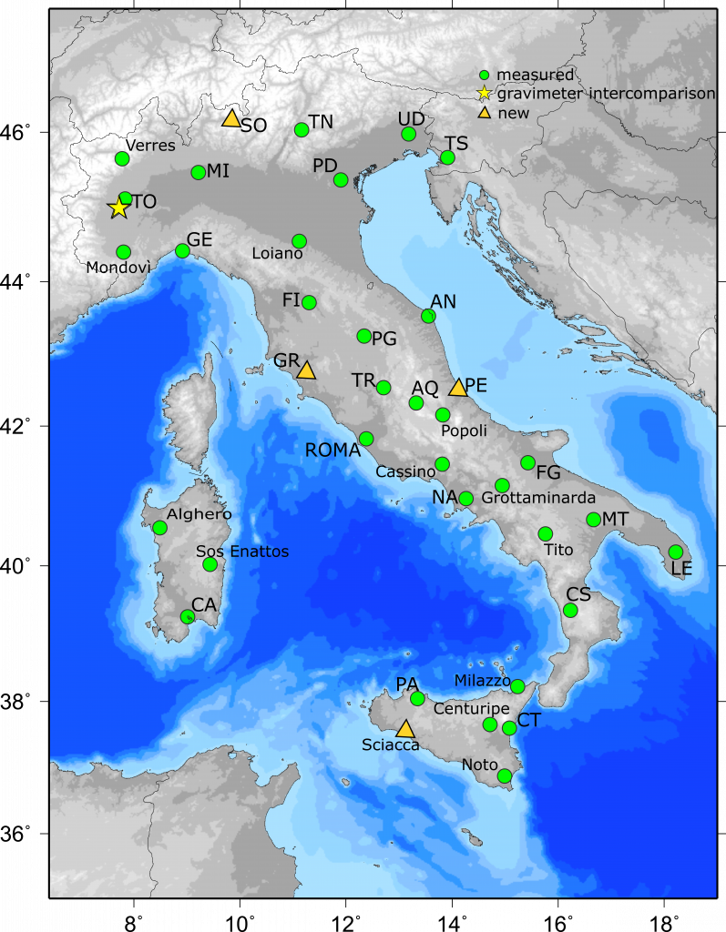
The G0 network and the IHRF/IHRS network design
The new gravity network, called G0 network, consists of stations (see the Figure) that are homogeneously distributed over Italy. Absolute gravity values have been measured according to the current international standard, as stated in IAG resolution #2.
The design of the network has been performed taking into account the existing absolute gravity points that were present in Italy, complementing them with new stations when required. In each G0 station, the vertical gravity gradient was estimated so to properly reduce the measured absolute gravity to ground level. Associated gravity points in the vicinity of the absolute stations were also established by relative gravity campaigns.
The gravity field campaigns have been assisted by topographic survey campaigns carried out using the highest surveying standard. GNSS observations have been integrated with terrestrial surveying methods in a common adjustment scheme, allowing cm precision estimation of the gravity stations coordinates in the current ITRF frame.
In the framework of the same PRIN2020 project, in a subset of stations of the G0 network, physical heights (orthometric heights) were also estimated according to IAG resolution #1. An overall revision of the Italian gravity database has been carried out thus leading to a better estimate of the gravity potential, the basis for the definition of an Italian physical height system coherent with the IHRS/IHRF concept.
The gravity database
The collected data will be available via a dedicated web service at INGV and INRiM. These data will also be sent for storage to the absolute gravity database maintained by the Bureau Gravimétrique International/Bundesamt fuer Kartographie und Geodaesie (Absolute gravity data and AGrav) where the absolute gravity data that will contribute to the new global absolute gravity reference system substituting IGSN71 are collected.
Remarkable impacts of the project are expected in geosciences (like Geodesy, Oceanography, Geophysics, Metrology) and in their technological applications.
Contacts:
- Politecnico di Milano: riccardo.barzaghi@polimi.it
- INGV: filippo.greco@ingv.it
- INRiM: a.germak@inrim.it
- Università di Roma «La Sapienza»: augusto.mazzoni@uniroma1.it